Regions of the UK
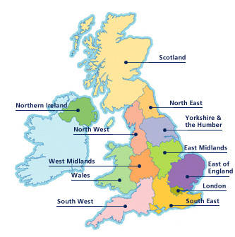
Every country is divided into unofficial sections known as regions. In America there are less regions than there are in England. Surprisingly, the larger a country, the less regions there are. Regions can be found anywhere, in your town, state, or city. There are many regions in England, however, there are none in Scotland, Wales, or Northern Ireland all of which make up the UK.
One of the more mountainous regions in the UK is the Scotland region, which is also a country. Scotland is famous for its freshwater lochs (lakes), and the well-known Loch Ness monster resides in the Loch Ness lake. Glasgow is a very popular city, with many architectural feats and castles. Edinburgh, which is similar to Glasgow, and is the capitol of Scotland.
Northern Ireland is mainly a mountainous region, like Scotland. This region holds Lough Neagh, which is the largest lake in all of the British Isles. Also in Northern Island is Giant's Causeway and the Mourne Mountains. For more information on the Giant's Causeway, see the Places page.
Northwestern England and Northeast England are similar in comparison geographically. However, while both regions are known for their beautiful rolling hills, Northeastern England is also known for its beautiful coastline, and Northwestern England is known for holding all three National parks. Northeast England also holds Hadrian's Wall (See Places).
The Yorkshire and Humber is made up of multiple rivers, and is divided into four parts; South, North, West Yorkshire and East Riding and North Lincolnshire. Because of the many rivers, the Yorkshire and Humber are very drained, nearly all of the rivers lead to the ocean. Also in Yorkshire and Humber is the popular Wakefield Cathedral.
Over the western half of England, by Wales and the West Midlands have resembling terrain. The farther west you go, the more rugged and mountainous it becomes. Wales is known for its rugged region, and so is the West Midlands, even containing the Black Mountain. Wales is also known as the origin that most of the stones in Stonehenge came from. Running through both Wales and the West Midlands, is the River Severn.
East Midlands and East of England are both swampy and flat. The most common job is farming due to the flat grassland. There are not many major cities in these two regions.
Southwestern and Southeastern England both have a similar landscape. Made up mainly of flat grassland occasionally some rolling hills, Southwestern England provided the perfect place for Stonehenge. Southeast England's main influence on the economy is London.
London, the largest city, the capitol, and the smallest region, is known well for the River Thames, and its many architectural feats, which you can find on the Places page. London is home to the Buckingham Palace, where the Queen often resides.
There are multiple regions in the UK each of them with their own type of terrain and style, making the UK the unique country that it is today.
